


Рабочие листы
к вашим урокам
Скачать
1 слайд
GEOGRAPHICAL POSITION OF THE UNITED KINGDOM OF GREAT BRITAIN AND NORTHERN IRELAND
Диана Рустамовна
ГБОУ СОШ №439 г. Москва
Учитель английского языка

2 слайд
л
GEOGRAPHICAL POSITION OF THE UNITED KINGDOM OF GREAT BRITAIN AND NORTHERN IRELAND
Абдульмянова Диана Рустамовна
ГБОУ Школа №439 г. Москва
Учитель английского языка

3 слайд
THE UNITED KINGDOM OF GREAT BRITAIN AND NOTHERN IRELAND
The official name of the country
we usually call England and occasionally Great Britain is
the United Kingdom of Great Britain and Northern Ireland

4 слайд
The United Kingdom of Great Britain and Northern Ireland is situated on the British Isles. The British Isles consist of 2 large islands, Great Britain and Ireland, and about 5000 small islands.
The British Isles are separated from the European continent by the North Sea and the English Channel. The western coast of Great Britain is washed by the Atlantic Ocean and the Irish Sea.
GREAT BRITAIN
THE ATLANTIC OCEAN
The Irish Sea
the North Sea
the English Channel
Geographical position

5 слайд
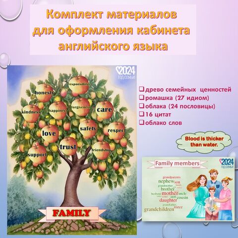
SYMBOLS
The United Kingdom is a constitutional monarchy and unitary state consisting of four countries: England, Northern Ireland, Scotland and Wales.

6 слайд
Англия
Шотландия
Уэльс
Северная Ирландия

7 слайд
the symbol of England is the red rose
the symbol of Wales is the daffodil
the symbol of Scotland is the thistle
The symbol of Nothern Ireland is the shamrock
Symbols

8 слайд
England
England is a country that is part of the United Kingdom. It shares land borders with Scotland to the north and Wales to the west; the Irish Sea is to the north west, the Celtic Sea to the south west and the North Sea to the east, with the English Channel to the south separating it from continental Europe.
. It is Br...")
9 слайд
London
London is the capital of England and the United Kingdom (UK). It is Britain's largest and most populous metropolitan area.

10 слайд
Scotland
Scotland is a country that is part of the United Kingdom. Occupying the northern third of the island of Great Britain, it shares a border with England to the south and is bounded by the North Sea to the east, the Atlantic Ocean to the north and west, and the North Channel and Irish Sea to the southwest. In addition to the mainland, Scotland includes over 790 islands including the Northern Isles and the Hebrides.

11 слайд
Edinburgh
Edinburgh is the capital city of Scotland. It is the second largest city in Scotland and the seventh-most populous in the United Kingdom.
The City of Edinburgh Council is one of Scotland's 32 local government council areas.

12 слайд
Wales
Wales is a country that is part of the United Kingdom, bordered by England to its east, and the Atlantic Ocean and Irish Sea to its west.

13 слайд
Cardiff
Cardiff is the capital, largest city and most populous county of Wales. The city is Wales' chief commercial centre, the base for most national cultural and sporting institutions, the Welsh national media, and the seat of the National Assembly for Wales.

14 слайд
Northern Ireland
Northern Ireland is one of the four countries of the United Kingdom. Situated in the north-east of the island of Ireland, it shares a border with the Republic of Ireland to the south and west.

15 слайд
Belfast
Belfast is the capital of and the largest city in Northern Ireland, a constituent country of the United Kingdom, but at the same time, located on the Island of Ireland. It is the seat of devolved government and legislative Northern Ireland Assembly. It is the largest urban area in Northern Ireland, the second-largest city on the island of Ireland and the 15th-largest city in the United Kingdom.

16 слайд
Britain is comparatively small, but there is hardly a country, in the world where such a variety of scenery can be found.
There are wild desolate mountains in the northern Highlands of Scotland - the home of the deer and the eagle.

17 слайд
The Pennine Range in northern
England
The Cambrian Mountains in Wales
( they are much lower)

18 слайд
In the extreme south of England are the famous chalk hills, some of which form the Dover Cliffs. The southern and south-eastern parts of the island lie in varied lowlands. The rivers of the region are short and of no great importance as waterways.
The longest of them is the "Father of London", the Thames, which is a little over 200 miles.
Britain's principal ports are London, Liverpool, Manchester, Hull, Glasgow.

19 слайд
They have splendid harbours, for the coast line is very indented. Owing to the shape of the country, any point in Great Britain is no more than 70 miles from the sea. Naturally, it's made the English race a sea - loving one.
The warm currents in the Atlantic Ocean influence the climate of Great Britain. The winters are not severely cold, while summers are rarely hot.

20 слайд
The fogs of London, often made severe by mixture with city smoke have a world - wide reputation, but the one not to be envied.
The British Isles are well - watered throughout the year. The cloudiness is rather dense, well over half the days of the year are overcast - fogs along the coast frequently hide the sun.

21 слайд
Rivers in Great Britain are seldom frozen and generally ice-free. The grass remains green all the year round. Thanks to climatic conditions, Britain in truth looks like one great well-ordered park with its old trees, green meadows and hedges.

22 слайд
What is the official name of
Great Britain?
1.England
2.Britain
3.The United Kingdom of Great Britain and Northern Ireland
Key: 3.The United Kingdom of Great Britain and Northern Ireland
Check yourself
Choose the right answer

23 слайд
WHAT COUNTRIES DOES THE UK CONSIST OF?
1. Ireland , England, Scotland, Wales
2. Northern Ireland, England, Scotland, Wales
3. Britain , England, Wales, Scotland
Key: 2. Northern Ireland, England, Scotland, Wales

24 слайд
WHAT SEPARATES THE UK FROM EUROPE?
1. The Pacific Ocean
2. The English Channel
3. The Atlantic Ocean
Key: 2. The English Channel

25 слайд
WHAT IS
THE CAPITAL OF WALES?
1. Cardiff
2. Edinburgh
3. Belfast
Key: 1. Cardiff

26 слайд
WHOSE
FLAG IS IT?
1. Scotland
2. Wales
3. England
Key: 3. England

27 слайд
WHOSE SYMBOL IS IT?
1. Wales
2. Scotland
3. England
Key: 2. Scotland

28 слайд
WHERE IS
THE FLAG OF THE UK?
1.
3.
Key: 2
2.

29 слайд
The UK is…
1. Constitutional monarchy
2. Parliamentary democracy
3. Absolutely monarchy
Key: 1. Constitutional monarchy

30 слайд
True or False:
The longest of them is the "Father of London", the Mississippi, which is a little over 200 miles.
Britain's principal ports are only London and Glasgow.
The fogs of London, often made severe by mixture with city smoke
Keys:
1-F (It is the Thames)
2-F (Britain's principal ports are London, Liverpool, Manchester, Hull, Glasgow.)
3-T

31 слайд
Put the article where necessary
…cloudiness is rather dense, well over half the days of the year are overcast - fogs along … coast frequently hide … sun.
… longest of them is the "Father of London", … Thames, which is a little over 200 miles.
The warm currents in … Atlantic Ocean influence the climate of… Great Britain.
Keys:
the, the, the
the, the
the, -
Thank you!
Рабочие листы
к вашим урокам
Скачать
6 665 143 материала в базе
Настоящий материал опубликован пользователем Газиева Диана Рустамовна. Инфоурок является информационным посредником и предоставляет пользователям возможность размещать на сайте методические материалы. Всю ответственность за опубликованные материалы, содержащиеся в них сведения, а также за соблюдение авторских прав несут пользователи, загрузившие материал на сайт
Если Вы считаете, что материал нарушает авторские права либо по каким-то другим причинам должен быть удален с сайта, Вы можете оставить жалобу на материал.
Удалить материалВаша скидка на курсы
40%
Курс профессиональной переподготовки
500/1000 ч.

Курс профессиональной переподготовки
300 ч. — 1200 ч.

Курс профессиональной переподготовки
300/600 ч.

Курс профессиональной переподготовки
300/600 ч.

Мини-курс
5 ч.

Мини-курс
6 ч.


Оставьте свой комментарий
Авторизуйтесь, чтобы задавать вопросы.